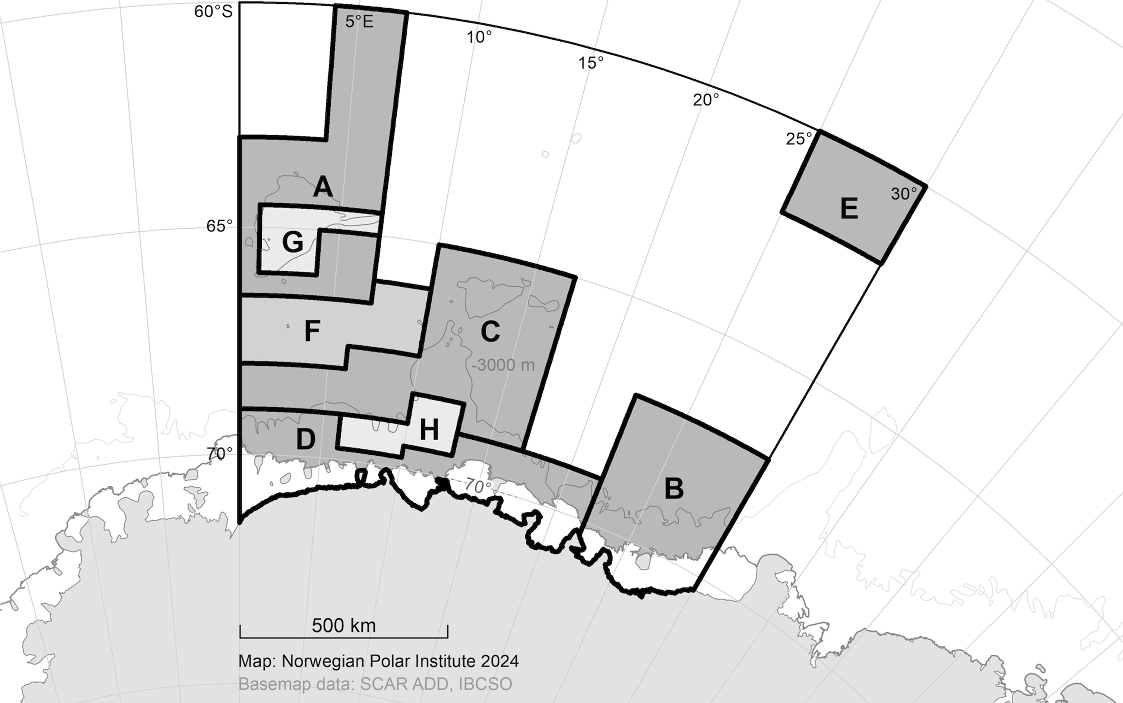
The proposed Weddell Sea Marine Protected Area (WSMPA) Phase 2 comprises 849 212 km2 within CCAMLR Statistical Subarea 48.6 east of the zero meridian. Its overarching aims are to protect the identified conservation and scientific values from potential local and global impacts related to Antarctic marine living resources for current and future generations and through spill-over assist long term rational use in the region.
The proposed MPA encompasses ecologically important and representative features in a bioregion where there are currently no marine protected areas and would constitute an important contribution in establishing a representative system of MPAs in the Convention Area. The proposed MPA includes unique oceanographic features and biological conditions that are crucial to shaping regional circumpolar and global oceanographic and biological processes. Within the proposed protection zones there are source and sink areas for Antarctic krill larvae, a key species to maintaining both ecosystem structure, as well as connective oceanographic pathways that transport these larvae between ecosystems beyond the proposed MPA boundaries.
The sea floor ecosystems include species richness comparable to tropical coral reefs including potential new species. Areas of high biological productivity support important foraging land-and ocean-based top predators and provide potential spillover effects to support potential future sustainable fisheries. The MPA includes areas of low climate change exposure and high biodiversity retention that are potentially important as climate refugia for cold-adapted species and ecological processes. The MPA will also serve as a valuable scientific reference area for research and monitoring, particularly for long-term climate observations and changes in the oceanographic conditions and pathways that have both regional and circumpolar implications for conservation.
There are three proposed management zones. The General Protection Zone (GPZ), comprising Areas A to E, each have distinct key conservation values and prohibit all fishing activities. The Seasonal Protection Zone (SPZ), Area F, provides protection during a particularly important life-history stage of Antarctic petrels, where fishing for krill is prohibited during a limited period of the year. The Fisheries Research Zone (FRZ), Areas G and H, correspond to existing CCAMLR Research Blocks (CM 41-04) and allow exploratory fishing for both toothfish and krill in accordance with relevant Conservation Measures. The FRZs will thus continue to inform the science-based management of the region’s Antarctic toothfish stock.
The scientific evidence to support the proposal is:
(1) Summarized in an online Atlas (Maud Atlas), which also provides links to relevant citations and data sources.
(2) Further detailed in SC-CAMLR-42/BG/02.
(3) Accessible through an interactive decision-support tool to support the analysis of the scientific basis for the proposed MPA (WSMPA2 Discussions Forum).
- (i) to protect essential habitats of key pelagic prey species. Key species include, Antarctic krill, ice/crystal krill, Antarctic silverfish and Antarctic lanternfish;
- (ii) to protect essential habitats of Antarctic toothfish (Dissostichus mawsoni);
- (iii) to protect essential habitats for key demersal fish species;
- (iv) to protect essential habitats for zoobenthic species. This includes areas with high habitat heterogeneity and species richness to preserve the ecological function of these habitats as “steppingstones” and sources for (re)colonization for associated c
- (v) to protect large-scale ecosystem areas and processes essential to maintaining the productivity and functional integrity of the ecosystem, including climate refugia areas for cold-adapted species;
- (vi) to protect essential pelagic habitats for pelagic and land-based top predators. This includes flying seabirds, penguins, seals and whales;
- (vii) to protect representative examples of circumpolar and regional pelagic marine environments;
- (viii) to protect representative examples of circumpolar and regional benthic marine habitats; and
- (ix) to provide scientific reference areas. This includes areas within the General Protection zone, the Seasonal Protection Zone and the Fisheries Research Zone designated as part of the Research and Monitoring Plan.
MPA Boundary shapefiles are available in the WSMPA2_Boundaries.zip folder
A systematic presentation of all elements including their justification, description, spatial and temporal details, and documentation, is available at https://tryggve.npolar.no/web/maudatlas/Atlas.html