The following information on the proposed WSMPA Phase 1 was provided by Germany:
The proposal to establish a WSMPA Phase 1 was first submitted to the CAMLR Commission in 2019. The proposal has since been further developed to take into account important scientific discoveries. The most recent proposal is shown under "Geographical Area/Zone".
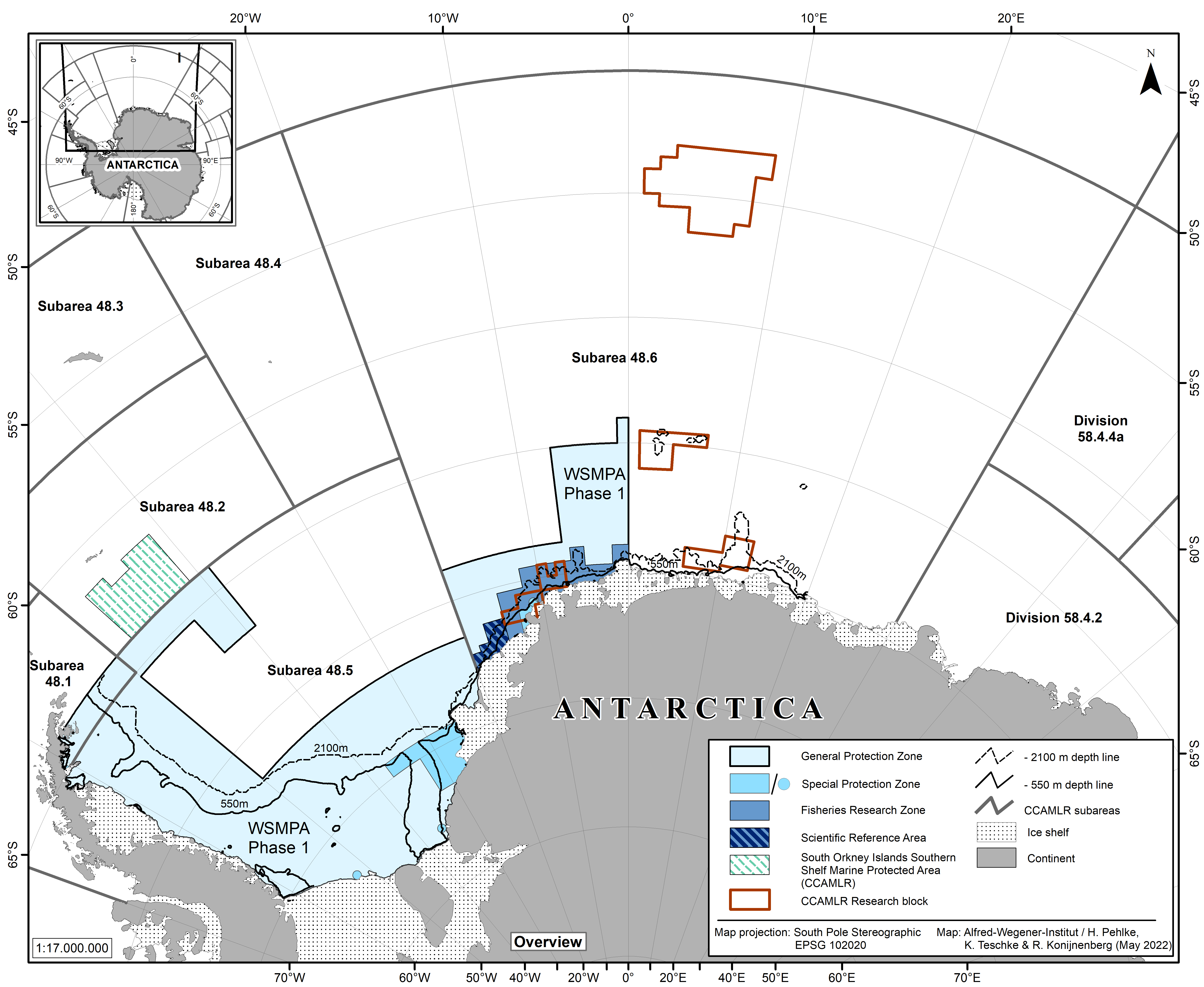
The proposed WSMPA P1 includes three management zones designed to achieve the specific objectives of the WSMPA P1: the General Protection Zone (GPZ), the Special Protection Zone (SPZ), and the Fisheries Research Zone (FRZ). In addition, the FRZ includes a Scientific Reference Area (SRA). Each zone allows certain activities and restricts others. The WSMPA P1 aims to protect representative examples of pelagic and benthic ecosystems, biodiversity and habitats (including relevant ecosystem components such as key species and top predators), protect vulnerable marine ecosystems and unique, rare or biodiverse habitats and features. It is also designed to provide climate change refugia for cold-adapted organisms, and contribute to the science-based management of the Antarctic toothfish stock through ongoing research.
Further information about the WSMPA Phase 1 proposal is available at https://wsmpa.de/en/.
- (S1) Protection of representative examples of pelagic and sea ice ecosystems and habitats, such as the areas along the shelf ice edge in the eastern and southern part of the WSMPA-Phase 1 with no or very low sea ice cover throughout the austral summer
- (S2) Protection of Antarctic krill (Euphausia superba), ice krill (Euphausia crystallorophias) and Antarctic silverfish (Pleuragramma antarctica) as key mid-trophic level species in the Antarctic food web as well as of important areas/ habitats for their life
- (S3) Protection of essential pelagic habitats for top predators such as flying seabirds, penguins and seals
- (S4) Protection of representative examples of benthic ecosystems and habitats, such as the ecologically important sponge associations on the shelf in the eastern and southern part of the WSMPA-Phase 1
- (S5) Protection of the integrity and life cycles of unique and diverse assemblages of suspension feeding animals, thereby providing source populations for (re)colonization
- (S6) Protection of rare and unique shallow (0-150m) sea floor areas with high habitat heterogeneity and species richness to preserve ecologic function of these areas as “stepping stones” and sources for (re)colonization for associated communities and species
- (S7) Protection of spawning areas and nesting sites of demersal fish species including areas where fish have been observed exhibiting parental care
- (S8) Protection of high productivity areas to support key ecosystem processes and functional integrity of the ecosystems, such as the Filchner overflow area
- (S9) Protection of marine ecosystems and habitats vulnerable to the effects of climate change, fishing and other human activities and critical to the function of local ecosystems to maintain and/or enhance resilience and adaptive capacity
- (S10) Protection of Antarctic toothfish (Dissostichus mawsoni) as key species of the upper trophic level in the Antarctic food web including all life history stages and their habitats
- (S11) Provision of scientific reference areas to monitor the natural variability and long-term changes on Antarctic marine living resources and to study the effects of climate change and human activities on Antarctic ecosystems
- (S12) Provision of areas for fisheries research in the FRZ to enhance the understanding of fish stocks, to test and verify stock and population hypotheses developed by CCAMLR for Antarctic toothfish in Area 48, and to study effects of fishing activities
The Southern Ocean may contribute a considerable amount to the proposed global network of marine protected areas (MPAs) that should cover about 10% of the world’s oceans in 2020. In the Antarctic, the Commission for the Conservation of Antarctic Marine Living Resources (CCAMLR) is responsible for this task, and currently Germany leads a corresponding scientific evaluation of the wider Weddell Sea region. Compared to other marine regions within the Southern Ocean, the Weddell Sea is exceptionally well investigated. A tremendous amount of data and information has been produced over the last 4 decades. Here, we give a systematic overview of all data sources collected in the context of the Weddell Sea MPA planning process. The compilation of data sources is comprised of data produced by scientists and institutions from more than 20 countries that were either available within our institutes, downloaded via data portals or transcribed from the literature. It is the first compilation for this area that includes abiotic data, such as bathymetry and sea ice, and ecological data from zooplankton, zoobenthos, fish, birds and marine mammals. All data layer products based on this huge compilation of environmental and ecological data are available from the data publisher PANGAEA via the six persistent identifiers at https://doi.org/10.1594/PANGAEA.899595 (Pehlke and Teschke, 2019), https://doi.org/10.1594/PANGAEA.899667 (Teschke et al., 2019a), https://doi.org/10.1594/PANGAEA.899645 (Teschke et al., 2019b), https://doi.org/10.1594/PANGAEA.899591 (Teschke et al., 2019c), https://doi.org/10.1594/PANGAEA.899520 (Pehlke et al., 2019a) and https://doi.org/10.1594/PANGAEA.899619 (Pehlke et al., 2019b). This compilation of data sources including the final data layer products will serve future research and monitoring well beyond the current MPA development process.
Supplementary material to baseline data
An integrated compilation of data sources for the development of a marine protected area in the Weddell Sea (2020)
Earth System Science Data, 12 (2), 1003-1023, doi: 10.5194/essd-12-1003-2020
Proposal to establish a Marine Protected Area across the Weddell Sea region (Phase 1) (2019)
Delegation of the European Union and its Member States and Norway
EU proposal to establish the Weddell Sea MPA (WSMPA) (2018)
Delegation of the European Union
Weddell Sea MPA data layers have been deposited with the data publisher PANGAEA (2018)
Teschke K, Pehlke H, Brey T
Informing the Working Group on Fish Stock Assessment about the revisions of the WSMPA proposal (2018)
Hain S, Teschke K, Pehlke H, Brey, T
Scientific background document in support of the development of a CCAMLR MPA in the Weddell Sea (Antarctica) – Version 2018 – Reflection on the recommendations by WG-EMM-17 and SC-CAMLR-XXXVI (2018)
Pehlke H, Teschke K, Brey T
Towards the development of a stock hypothesis for Antarctic toothfish (Dissostichus mawsoni) in Subarea 48.6 in the context of Area 48 (2018)
Soeffker M, Riley A, Belchier M, Teschke K, Pehlke H, Graham J, Somhlaba S, Namba T, Darby C.
Predicting fishing ground accessibility in the Antarctic Weddell Sea (2018)
Pehlke H, Teschke K, Brey T
Scientific background document in support of the development of a CCAMLR MPA in the Weddell Sea (Antarctica) – Version 2017 – Reflection of the recommendations by WG-EMM-16 and SC-CAMLR-XXXV (2017)
Teschke K, Pehlke H, Brey T
Proposal on a conservation measure establishing the Weddell Sea Marine Protected Area (WSMPA) (2016)
Delegation of the European Union
Towards mapping and assessing antarctic marine ecosystem services – The Weddell Sea case study (2016)
Deininger M, Koellner T, Brey T, Teschke K (2016)
Scientific background document in support of the development of a CCAMLR MPA in the Weddell Sea (Antarctica) - Version 2016; Part C: Data analysis and MPA scenario development (2016)
Teschke K, Pehlke H, Deininger M, Jerosch K, Brey T on behalf of the German Weddell Sea MPA project team
Scientific background document in support of the development of a CCAMLR MPA in the Weddell Sea (Antarctica) - Version 2016; Part B: Description of available spatial data (2016)
Teschke K, Pehlke H, Brey T on behalf of the German Weddell Sea MPA (WSMPA) project team, with contributions from the participants at the International Expert Workshop on the WSMPA project (7-9 April 2014, Bremerhaven)
Scientific background document in support of the development of a CCAMLR MPA in the Weddell Sea (Antarctica) - Version 2016; Part A: General context of the establishment of MPAs and background information on the Weddell Sea MPA planning area (2016)
Teschke K, Beaver D, Bester MN, …, van Opzeeland IC, von Nordheim H, Brey T (+ 43 co-authors)
Proposal to establish a Marine Protected Area across the Weddell Sea region (Phase 1) (2020)
Delegations of the European Union and its Member States and Norway
Evaluation of the achievement of WSMPA conservation features and their target values for WSMPA Phase 1 (2020)
K. Teschke, S. Hain, H. Pehlke, P. Brtnik, G. Griffith, A. Lowther and T. Brey
Scientific background document in support of the development of a CCAMLR MPA in the Weddell Sea (Antarctica) - Version 2015; Part C: Data analysis and MPA scenario development (2015)
Teschke K, Pehlke H, Deininger M, Douglass L, Brey T on behalf of the German Weddell Sea MPA project team
Scientific background document in support of the development of a CCAMLR MPA in the Weddell Sea (Antarctica) - Version 2015; Part B: Description of available spatial data (2015)
Teschke K, Pehlke H, Brey T on behalf of the German Weddell Sea MPA (WSMPA) project team, with contributions from the participants at the international Expert Workshop on the WSMPA project
Scientific background document in support of the development of a CCAMLR MPA in the Weddell Sea (Antarctica) - Version 2019; Part A: General context of the establishment of MPAs and background information on the Weddell Sea MPA planning area (2015)
Teschke K on behalf of the Weddell Sea MPA (WSMPA) project team
Progress report on the scientific data compilation and analyses in support of the development of a CCAMLR MPA in the Weddell Sea (Antarctica) (2014)
Teschke K, Jerosch K, Pehlke, H, Brey T
Proposal for the establishment of a marine CCAMLR MPA in the Weddell Sea (Antarctica) – First conceptual outline (2013)
Teschke K, Dorschel B, Gutt J, Hain S, Hellmer H, Jerosch K, Knust R, Kock KH, Schlüter M, Siegel V, Brey T
Germany's Proposal for a Marine Protected Area in Antarctica (2019)
Federal Ministry of Food and Agriculture
8 Reasons for a Marine Protected Area in the Weddell Sea (2016)
Alfred Wegener Institute
Conserving the unspoiled Weddell Sea in the Antarctic (2016)
Alfred Wegener Institute
Draft Conservation Measure establishing a Marine Protected Area across the Weddell Sea region (2021)
Delegations of the European Union and its Member States, Norway, Uruguay, Australia, the
United Kingdom, New Zealand, the USA, the Republic of Korea, India and Ukraine
Proposal to establish a Marine Protected Area across the Weddell Sea region (Phase 1) (2020)
Delegations of the European Union and its Member States and Norway
Evaluation of the achievement of WSMPA conservation features and their target values for WSMPA Phase 1 (2020)
K. Teschke, S. Hain, H. Pehlke, P. Brtnik, G. Griffith, A. Lowther and T. Brey
Draft Conservation Measure establishing a Marine Protected Area across the Weddell Sea region (2021)
Delegations of the European Union and its Member States, Norway, Uruguay, Australia, the United Kingdom, New Zealand, the USA, the Republic of Korea, India and Ukraine
Draft conservation measure establishing a Marine Protected Area across the Weddell Sea region (2022)
Delegations of the EU and its Member States, Norway, Uruguay, Australia, the United Kingdom, New Zealand, the USA, the Republic of Korea, India and Ukraine
Draft conservation measure establishing a Marine Protected Area across the Weddell Sea region (2022)
Delegations of the EU and its Member States, Norway, Uruguay, Australia, the United
Kingdom, New Zealand, the USA, the Republic of Korea, India and Ukraine
Draft conservation measure for a Weddell Sea Marine Protected Area - Phase 1 (2023)
Delegations of the EU and its Member States, Norway, Uruguay, Australia, the United Kingdom, New Zealand, the United States of America, the Republic of Korea, India, Ukraine and Chile